Characterization of the Ashepoo-Combahee-Edisto (ACE) Basin, South Carolina
Surface Water

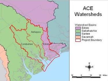
The ACE Basin Characterization study area is located in the lower coastal plain of South Carolina; however, the headwaters of many of its rivers and streams originate in the middle or upper coastal plain. All of the surface water flowing into the ACE Basin eventually empties into the Atlantic Ocean via St. Helena Sound (SCWRC 1972). The South Carolina Department of Natural Resources recognizes two river sub-basins in the ACE Basin: the Edisto River sub-basin and the Combahee-Coosawatchie River sub-basin.
The Edisto River sub-basin is entirely within South Carolina and drains the following four tributaries: South Fork Edisto River, North Fork Edisto River, Edisto River, and Four Hole Swamp. The Edisto River is tidally influenced within 21.7 km (35 mi) of the coast and the saltwater interface extends approximately 12.4 km (20 mi) inland during high tide. Stream flow in the Edisto River is substantial (74 m3/sec, or 2,614 cubic feet/sec, at Givhan's Ferry) and fairly constant (SCWRC 1983). Surface water in the Edisto River sub-basin supplies approximately 93% of the total water demand for public supply and agricultural irrigation. In particular, the City of Charleston withdraws large amounts (65 million gallons/day) of Edisto River water upstream of Givhans. Total water use in the Edisto River sub-basin is projected to increase 52% by the year 2020, with agriculture and thermoelectric power plants being the leading gross water users (SCWRC 1983).
The major freshwater rivers draining the Combahee-Coosawhatchie River sub-basin are the Salkehatchie, Coosawhatchie, and Ashepoo rivers. The Little Salkehatchie and Salkehatchie rivers are the major tributaries to the tidally influenced Combahee River. The Combahee and Ashepoo Rivers drain into the ACE Basin; however, the Coosawhatchie River drains outside of the Basin into Port Royal Sound. The freshwater-saltwater interface for the Combahee and the Ashepoo rivers are located about 24.8 km (40 mi) inland and 18.6 km (30 mi) inland, respectively. The largest surface water withdrawal in this sub-basin is related to agricultural practices with most water use coming from ground water sources.
