Overview
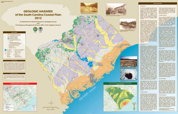
The Geologic Hazards of the South Carolina Coastal Plain map has been designed as a planning tool for use by emergency managers for the response to, and recovery from, a hazardous geologic event. Such events include earthquakes, landslides, or sinkhole formation(s). It also may be useful to land-use planners and regulators as a generalized guide to regional hazard mitigation actions. This deterministic map assumes that the occurrence of geologic hazards in the Coastal Plain region of South Carolina is related to the underlying geologic conditions.
References for Geologic Hazards Map (GGMS-5)
Amick, D.C., 1990, Paleoliquefaction investigations along the Atlantic seaboard with emphasis on the prehistoric earthquake chronology of Coastal South Carolina: Ph.D. dissertation, University of South Carolina, 204p.
Bollinger, G.A., 1977, Reinterpretation of the intensity data for the 1886 Charleston, South Carolina, earthquake, in, Rankin, D.W., ed., Studies elated to the Charleston, South Carolina earthquake of 1886 – a preliminary report: U.S. Geological Survey Professional Paper 1028, p. 17 – 32. https://pubs.usgs.gov/pp/1028/report.pdf
Doar, W.R., III, 2003, Geologic map of the Beaufort quadrangle, Beaufort County, South Carolina: South Carolina Geological Survey, Geologic Quadrangle Map 22, scale 1:24,000. http://www.dnr.sc.gov/geology/publications.htm#gqm22
Doar, W.R., III, and Willoughby, R.H., 2006, Revisions of the Pleistocene Dorchester and Summerville scarps, the inland limits of the Penholoway terrace, central South Carolina: Geological Society of America Abstracts with Programs, Vol. 38, No. 3, p. 18.
Dura-Gomez, Inmaculada, and Talwani, Pradeep, 2009, Finding faults in the Charleston area, South Carolina: 1. Seismological data: Seismological Research Letters, v. 80, no. 5, p. 883-900. http://www.seis.sc.edu/projects/SCSN/history/Publications/Dura-Gomez%20and%20Talwani,%202009.pdf
Dutton, C.E., 1889, The Charleston earthquake of August 31, 1886: U.S. Geological Survey Ninth Annual Report, 1887-88, p. 203-528.
Howard, C.S., 2010, Observations of the 1886 Charleston earthquake in central South Carolina, evidence of fault reactivation: South Carolina Geology, v.47, p. 33-44. http://www.dnr.sc.gov/geology/scgeology.htm
Hockensmith, B.L., and Pelletier, A.M., 1987, Investigation of sinkhole occurrences at Goretown, near Loris, South Carolina: South Carolina Water Resources Commission, Open-File Report – 11, 31 p. http://hydrology.dnr.sc.gov/pdfs/reports/SCWRC_Open-File_Report_11.pdf
Maybin, A.H., Clendenin, C.W., Jr., and Daniels, D.L., 1998, Structural features of South Carolina: South Carolina Geological Survey General Geologic Map Series 4, 1:500,000. http://www.dnr.sc.gov/geology/publications.htm#ggms
Obermeier, S.F., Jacobson, R.B., Smoot, J.P., Weems, R.E., Gohn, G.S., Monroe, J.E., and Powars, D.S., 1990, Earthquake-induced liquefaction features in the coastal setting of South Carolina and in the fluvial setting of the New Madrid seismic zone: U.S. Geological Survey Professional Paper 1504, 44 p. https://pubs.usgs.gov/pp/1504/report.pdf
Obermeier, S.F., Weems, R.E., and Jacobson, R.B., 1987, Earthquake-induced liquefaction features in the coastal setting of South Carolina region: U.S. Geological Survey Open-File Report 87-504, 17 p. https://pubs.usgs.gov/of/1987/0504/report.pdf
Schaeffer, W.T., 1995, Paleoliquefaction investigations near Georgetown, South Carolina: M.Sc. Thesis, University of South Carolina.
Talwani, P., and Cox, J., 1985, Paleoseismic evidence for recurrence of earthquakes near Charleston, South Carolina: Science, v. 229, p. 379-381.
Weary, D.J., 2008, Preliminary map of potentially karstic carbonate rocks in central and southern Appalachians states: U.S. Geological Survey Open-File Report 2008-1154, Available online only at https://pubs.usgs.gov/of/2008/1154/, last accessed 15 April 2011.

