Overview
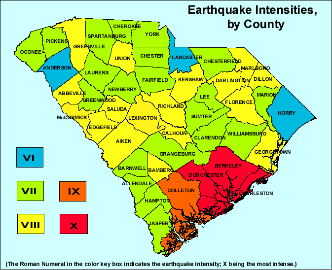
This map shows earthquake intensities, by county, based on the Modified Mercalli Intensity Scale. The intensities shown on this map are the highest likely under the most adverse geologic conditions that would be produced by a combination of the August 31, 1886, Charleston, S.C., earthquake and the January 1, 1913, Union County, S.C., earthquake. The Rossi-Forel Scale initially used to describe the January 1, 1913, Union County, S.C., earthquake is considered comparable to the Modified Mercalli Intensity Scale for the purpose of developing this map.

Modified Mercalli Intensity Scale
Intensity is a numerical index describing the effects of an earthquake on the surface of the Earth, on man, and on structures built by man. The intensities shown on the map below are the highest likely under the most adverse geologic conditions. There will actually be a range of intensities within any small area such as a town or county, with the highest intensity generally occurring at only a few sites. Earthquakes represented on the map occurred during August 31, 1886, Charleston, SC., earthquake and January 1, 1913, Union County, SC., earthquake.
- People do not feel any Earth movement.
- A few people might notice movement.
- Many people indoors feel movement. Hanging objects swing.
- Most people indoors feel movement. Dishes, windows, and doors rattle. Walls and frames of structures creak. Liquids in open vessels are slightly disturbed. Parked cars rock.
- Almost everyone feels movement. Most people are awakened. Doors swing open or closed. Dishes are broken. Pictures on the wall move. Windows crack in some cases. Small objects move or are turned over. Liquids might spill out of open containers.
- Everyone feels movement. Poorly built buildings are damaged slightly. Considerable quantities of dishes and glassware, and some windows, are broken. People have trouble walking. Pictures fall off walls. Objects fall from shelves. Plaster in walls might crack. Some furniture is overturned. Small bells in churches, chapels, and schools ring.
- People have difficulty standing. Considerable damage in poorly built or badly designed buildings, old walls, spires and other structures. Damage is slight to moderate in well-built buildings. Numerous windows are broken. Weak chimneys break at roof lines. Cornices from towers and high buildings fall. Loose bricks fall from buildings. Heavy furniture is overturned and damaged. Some sand and gravel stream banks cave in.
- Drivers have trouble steering. Poorly built structures suffer severe damage. Ordinary substantial buildings partially collapse. Damage slight in structures especially built to withstand earthquakes. Tree branches break. Houses not bolted down might shift on their foundations. Tall structures such as towers and chimneys might twist and fall. Temporary or permanent changes may occur in springs and wells; sand and mud are ejected in small amounts.
- Most buildings suffer damage. Houses that are not bolted down move off their foundations. Some underground pipes are broken. The ground cracks conspicuously. Reservoirs suffer severe damage.
- Well-built wooden structures are severely damaged and some destroyed. Most masonry and frame structures are destroyed, including their foundations. Some bridges are destroyed. Dams are seriously damaged. Large landslides occur. Water is thrown on the banks of canals, rivers, and lakes. Railroad tracks are bent slightly. Cracks are opened in cement pavements and asphalt road surfaces.
- Few if any masonry structures remain standing. Large, well-built bridges are destroyed. Wood frame structures are severely damaged, especially near epicenters. Buried pipelines are rendered completely useless. Railroad tracks are badly bent. Water mixed with sand and mud is ejected in large amounts.
- Damage is total, and nearly all works of construction are damaged greatly or destroyed. Objects are thrown into the air. The ground moves in waves or ripples. Large amounts of rock may move. Lakes are dammed, waterfalls formed, and rivers are deflected.