SC Floodplain Mapping Initiative
The citizens of the State of South Carolina face significant hazards from floods and hurricanes, The Federal Emergency Management Agency (FEMA) flood hazard maps are one of the essential tools for flood hazard mitigation in the United States.
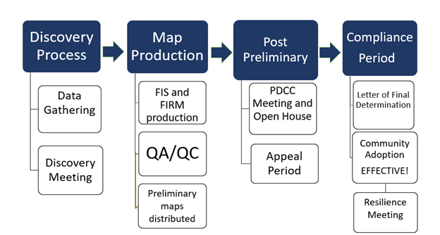
Understanding the need for current, accurate flood maps the South Carolina Department of Natural Resources became a Cooperating Technical Partner (CTP) with the Federal Emergency Management Agency (FEMA) in 1999. The State of South Carolina is committed to reducing flood risks within the State. Through the CTP program the SCDNR works with FEMA to update flood hazard information for all of the State's 46 counties.
In 2009, FEMA transitioned to the Risk Mapping, Assessment, and Planning (Risk MAP) program. The vision for Risk MAP is to deliver quality data that increases public awareness and leads to action that reduces risk to life and property.
Use the SCDNR Flood Risk Map Progress Site to learn about the flood map updates in your watershed.
Flood Maps
The FEMA Flood Insurance Rate Maps (FIRMs) for the State can be viewed in two ways:
- FEMA's Map Service Center (msc.fema.gov) provides multiple ways to access the flood information. The home page allows a search by address. Additionally, there are products that are available for download, such as the FIRM panels, FIS (Flood Insurance Study), and the DFIRM database (GIS shapefiles). Historical flood mapping information can also be found here.
- The SC Flood Inundation and Mapping for Action or the IMPACT (scfloodimpact.com) website is also available for viewing the flood maps. The Floodplain Map Viewer allows a search by address to view the flood zone. If there are preliminary maps available, the map viewer will toggle between the preliminary and effective maps to see the updates.
- Also, keep in mind that each participating community keeps a paper copy of the FIRMs on file in the local floodplain manager's office.
Questions regarding floodplain development should be directed to the Local NFIP Administrator (PDF) (https://www.dnr.sc.gov/water/flood/documents/nfipadmindirectory2021.pdf) for your community.
Hydrologic and Hydraulic Models
The hydrologic and hydraulic models that were created by SCDNR to develop the FIRMs are available on the IMPACT (scfloodimpact.com) website for registered users. The local Floodplain Administrator can register for access to this information. The registration must be approved by our office. If they are not available on the IMPACT website, they will need to be obtained from FEMA.
In certain cases, the models can be used as Best Available Data to establish a BFE in an unnumbered A zone. You can view these step by step instructions on getting a Water Surface Elevation (WSE) from an A zone H&H model
Mapping Process


 Facebook