Shellfish Grounds: Little River to Winyah Bay
Recreational Harvesting
 Information on this page applies to recreational harvest only. Commercial harvesters must obtain appropriate
permits and maps from the Marine Permit office at 217 Fort Johnson Road, Charleston. Call (843) 953-9311 for
more information on commercial harvesting.
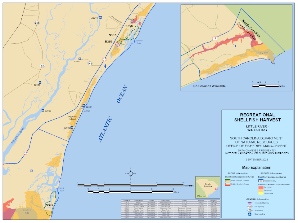
Recreational harvesting is allowed on state and public shellfish grounds. State grounds are labeled "S###" and public shellfish grounds are labeled "R###". Recreational harvesting is not allowed on Culture Permits or Mariculture Permits unless the harvester has written permission from the permit holder.
Shading denotes SCDES harvest classifications based on water quality. It is not safe to consume shellfish from areas shaded red or orange. All shellfish grounds are subject to closure after heavy rainfall or pollution spills. SCDES announces such closures in your local newspaper and on the shellfish hotline 1-800-285-1618. Maps of the closed areas are also available at this SCDES site. The SCDES management areas are outlined in blue. Additional information on SCDES shellfish ground classifications may be found at https://www.scdhec.gov/food-safety/shellfish-monitoring-program-overview/shellfish-maps.
Use the table below to select detailed maps of individual shellfish grounds. If you have any questions about shellfish maps you may call SCDNR at (843) 953-9841 or (843) 953-9391. To request paper copies please call (843) 953-9854.
Select the link below to view a larger version of the map above.
Little River to Winyah Bay area map - PDF
Specific Shellfish Ground Maps
Shellfish Ground Maps will be available here. Please make sure you are using a current season map – the season dates are at the top of every map. Grounds which do not appear in the tables below are not available for the recreational harvest season.
You'll need the free Adobe Reader to view the map files. If you don't have the reader please visit Adobe web site and download the reader. All Adobe files are 4M or greater in file size.
Little River to Winyah Bay
Public Shellfish Grounds
| PSG | Geographic Description | Status | Date Open |
Date Closed * |
Map ** |
|---|---|---|---|---|---|
| R-355 | Lachicotte Oyster Creek | Partially Closed – SCDES | 1-October | 15-May | Adobe PDF |
State Shellfish Grounds
| SSG | Geographic Description | Status | Date Open |
Date Closed * |
Map ** |
|---|---|---|---|---|---|
| S-342 | Jones Creek | 1-October | 15-May | Adobe PDF | |
| S-357 | Drunken Jack Island | Partially Closed - SCDES | 1-October | 15-May | Adobe PDF |
| S-358 | Murrells Inlet | Partially Closed - SCDES | 1-October | 15-May | Adobe PDF |
* Closure dates for all Shellfish Grounds are subject to change. Check your local newspaper or call SCDNR at 1-843-953-9300.
** Provided by the South Carolina Department of Natural Resources, Office of Fisheries Management, Shellfish Management Program.

