
Characterization of the Ashepoo-Combahee-Edisto (ACE) Basin, South Carolina
Plants
Thirty plant community types were identified and classified by The Nature Conservancy during botanical surveys of 28 natural areas in the ACE Basin (TNC 1993). The dominant vegetation types in the highest strata of the habitat define the plant communities. Three of the 30 plant communities (maritime dry grassland, maritime shrub thicket, and barrier island forest) are on the barrier and barrier-like islands. Estuarine wetlands contain four plant communities (salt marsh, salt flat, salt scrub thicket, brackish marsh), and 16 community types are in palustrine wetlands that are divided into two major categories: tidal and inland. There are 12 communities (depression meadow, bay forest, non-riverine swamp forest, pond pine woodland, pocosin, Carolina bay, maritime wet grassland, shrub swamp, depression pond complex, inland freshwater marsh, swamp tupelo pond, stream head pocosin) in inland wetlands that are defined as habitats having no hydrologic connection to major water bodies. Four communities (tidal marsh, bald cypress-tupelo swamp, bottomland hardwood, and spruce pine-mixed hardwood community) occur in tidal wetlands. The upland areas on the marsh islands and the mainland areas contain seven plant community types (loblolly pine-mixed hardwood forest, longleaf pine flatwoods, oak-hickory forest, South Atlantic inland maritime forest, Southern mixed hardwood forest, subxeric pine-scrub oak sandhill, and temperate shell midden woodland (TNC 1993).
The physical environment of the habitat affects the types and distribution of plants occurring in each community type. Van der Valk (1974) demonstrated that the zonation of maritime plant species is strongly influenced by the differential tolerance of the plants to sand burial and sand movement. On ACE Basin barrier islands where sand movement and salt spray deposition is high, clonal species such as sea oats dominate. As the intensity of sand movement and salt spray decreases, the numbers of inland species (e.g., camphorweed, fleabane, beach pea, and evening primrose) increase (TNC 1993). In the most stable areas, TNC (1993) noted that woody species, including live oak, cabbage palmetto, and wax myrtle characterize the plant communities.
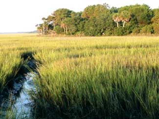
Salinity and tidal regime are the two most important environmental factors influencing plant compositions and distribution in the estuarine communities (Tiner 1977; TNC 1993). At the fresher end of the estuarine wetland zone (salinity about 0.5 ppt), a mixture of freshwater and brackish plant species (e.g., needlerush [Juncus roemerianus]) is common in the low and high marsh zones (Tiner 1977; TNC 1993). Near the salt marsh upstream boundary, the species composition of the ACE Basin brackish marsh resembles the high marsh zone of the salt marsh (Tiner 1977). As the salinity rises above 10 ppt, smooth cordgrass becomes an important component of the salt marsh. The distribution of plant species within a marsh also changes in response to a salinity gradient that exists from the mean low tide mark to the marsh-upland border (Adams 1963; Stalter 1968). Near the brackish-freshwater marsh border, the flood water salinity level is about 0.5 ppt, and the range of freshwater plant species extends to the mean low tide mark (Tiner 1977). Where the salinity fluctuates between 5 and 10 ppt, freshwater species are restricted to the marsh-upland border brackish species such as giant cordgrass dominate the low marsh, and smooth cordgrass forms a monoculture stand in the low marsh (flooded daily by the tides).
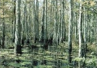
The major factor affecting the plant community distributions in the palustrine ecosystem is hydrology, especially the timing, duration, and depth of flooding (Wharton et al. 1982; Sharitz and Gresham 1998). Bald cypress, water tupelo, and swamp blackgum are generally found in wetlands where the substrate is inundated or saturated throughout the growing season (Wharton et al. 1982). The remaining tidal plant species on the floodplains require some period of drawdown during the growing season. Here, oaks (Quercus spp.) and a variety of other hardwoods as well as a few pine species thrive. As the duration of yearly flooded events decrease, the numbers of shrub and herbaceous (nonwoody) species in these communities increase. The species composition of inland wetlands also corresponds to the flooding regime. Pocosin and Carolina bay plant communities are the only fire-maintained wetlands in the ACE Basin, and the frequency and intensity of these fires control the distribution of plant species in these wetlands (Wharton 1978).
Soil moisture level and organic matter content, and the frequency of fires affect the distribution of plant species in the upland communities of the ACE Basin (Quarterman and Keever 1962; Monk 1968; Veno 1976; TNC 1993). The low, loamy soils of the ACE Basin favor the establishment of mesophytic hardwoods such as swamp laurel oak, and sweetgum; whereas, a mixture of pines and scrub oaks characterizes the well-drained, coarse sands on the sloping terrain of the ACE Basin's mainland areas. The sandy soils of the coastal islands within the ACE Basin NERR support the South Atlantic inland maritime forest community, and the soils that contain large deposits of shells are vegetated by the temperate shell midden woodland plant association. These two communities are considered variants of the barrier island forest community because they are also subjected to salt spray. Areas that burn regularly (i.e., once each year) are dominated by pyric (fire tolerant or loving) species such as longleaf pine (Pinus palustris).
Land use practices also affect the types and distribution of plant species in the ACE Basin study area. During the Antebellum Era, bald cypress-dominated swamps along the navigable portions of these rivers were cleared and planted in rice. Agriculture, livestock grazing, and turpentine production accounted for the loss of longleaf pine-dominated forest prior to 1900. From the 1890s to 1920s, an era of intensive logging in Colleton County, most of the remaining old-growth longleaf pines and bald cypress were felled. The fire exclusion policies of the mid-1900s resulted in further decline in the longleaf pine populations. From 1959 to 1972, approximately 687 ha (1,698 ac) of brackish marshes in the estuarine ecosystem along the Ashepoo, Combahee, and South Edisto Rivers were impounded to increase waterfowl habitat, primarily for hunting (Morgan 1974). Many landowners also repaired the rice field dikes and developed water management techniques to enhance the value of the fields as waterfowl habitat. The techniques employed by waterfowl managers to eradicate plants of low nutritive value are significantly changing the species composition of these impounded brackish marsh communities (Morgan 1974; Prevost 1988 1991). Thus, the populations of estuarine species such as black needlerush and big cordgrass and of several freshwater species (e.g., alligatorweed and bladderworts) have been reduced. Development on Edisto Island, an ACE Basin barrier island, has dramatically affected the plant zonation in the maritime ecosystem.
Quantitative information about the community structure and soil conditions of ACE Basin's ecosystems is needed before any conclusions can be drawn about the effects that natural and artificial perturbations have on the functioning of the plant communities. To understand these processes more fully, future studies must consider the effects of the interactions of hydrology, soil regimes, community type (and stand history), and species life history on the distribution of plant species and the production of biomass. As these processes are better elucidated, we will improve our ability to assess the wetlands and will be able to manage these plant communities in a sustainable manner for future generations.