
For previously issued drought statements see the archived status reports.
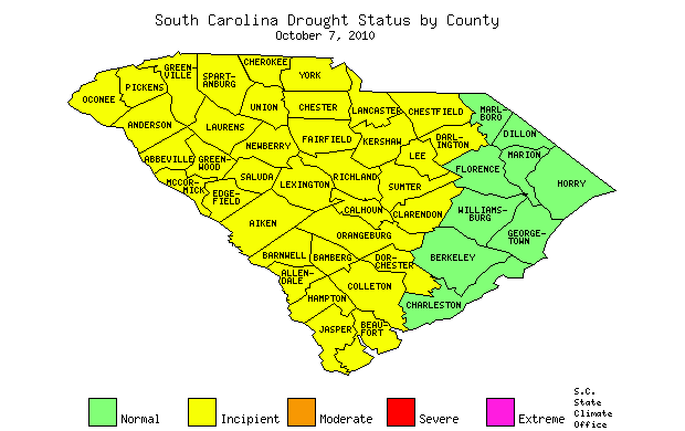
Table of all counties and drought status.Heavy rainfall last week has alleviated drought conditions in nine counties; Charleston, Berkeley, Georgetown, Williamsburg, Horry Marlboro, Dillon, Marion, and Florence (see table below). According to Mark Malsick, South Carolina State Climatology Office Severe Weather Liaison, "Last week's heavy rain was due to several distinct, inter-related weather features. A passing cold front brought the first rain across the state on Sunday and Monday. This front stalled offshore and became a conduit that tapped into tropical Gulf of Mexico moist air. Midweek, as the remnants of Tropical Storm Nicole streamed north, a compact low pressure center formed on the stalled front triggering more thunderstorms and heavy rain for the coast and Pee Dee region."
Hope Mizzell, S.C. State Climatologist, "September was on tap to be one of the driest on record until last week's rain. For some locations, like Andrews, it went from being the second driest September (0.38") to the fifth wettest (10.18") in 50 years. The very dry conditions preceding the rain helped minimize the flooding impacts. All locations received welcome rain last week, but 37 counties will remain in drought because the rainfall amounts were not sufficient to improve all drought indicators."
25-30 September, 2010 Rainfall Summary: (*Community Collaborative Rain, Hail & Snow Network (COCORAHS) Stations)
| Station | Rainfall Totals |
|---|---|
| Myrtle Beach 5.3 W* | 14.15" |
| Murrells Inlet 0.3 SSW* | 12.28" |
| Hemingway 11.6 SE* | 11.54" |
| Bennettsville 1.2 SE* | 10.34" |
| North Inlet | 10.43" |
| Conway | 10.20" |
| McClellanville | 9.96" |
| Andrews | 9.80" |
| Georgetown | 9.44" |
| Quinby | 8.85" |
| Mullins | 8.81" |
| Loris | 8.75" |
| Kingstree | 8.73" |
| Gallivants Ferry | 8.60" |
| Bennettsville | 8.49" |
| Cades | 8.38" |
| North Myrtle Beach | 8.27" |
| Florence | 8.13" |
| Mount Pleasant 7.9 NNE* | 4.40" |
| Jamestown | 8.04" |
| Charleston Air Force Base | 6.74" |
| Current Drought Status by County | ||||
|---|---|---|---|---|
| Normal | Incipient | Moderate | Severe | Extreme |
| County Status |
County Status |
County Status |
County Status |
County Status |
| ABBEVILLE Incipient |
AIKEN Incipient |
ALLENDALE Incipient |
ANDERSON Incipient |
BAMBERG Incipient |
| BARNWELL Incipient |
BEAUFORT Incipient |
BERKELEY Normal |
CALHOUN Incipient |
CHARLESTON Normal |
| CHEROKEE Incipient |
CHESTER Incipient |
CHESTERFIELD Incipient |
CLARENDON Incipient |
COLLETON Incipient |
| DARLINGTON Incipient |
DILLON Normal |
DORCHESTER Incipient |
EDGEFIELD Incipient |
FAIRFIELD Incipient |
| FLORENCE Normal |
GEORGETOWN Normal |
GREENVILLE Incipient |
GREENWOOD Incipient |
HAMPTON Incipient |
| HORRY Normal |
JASPER Incipient |
KERSHAW Incipient |
LANCASTER Incipient |
LAURENS Incipient |
| LEE Incipient |
LEXINGTON Incipient |
MARION Normal |
MARLBORO Normal |
MCCORMICK Incipient |
| NEWBERRY Incipient |
OCONEE Incipient |
ORANGEBURG Incipient |
PICKENS Incipient |
RICHLAND Incipient |
| SALUDA Incipient |
SPARTANBURG Incipient |
SUMTER Incipient |
UNION Incipient |
WILLIAMSBURG Normal |
| YORK Incipient |
||||
| SC Drought Response Committee Meeting, October 7, 2010 Sign-In sheet | |
|---|---|
| Name & Agency | Name & Agency |