DNR News** Archived Article - please check for current information. **
SCDNRs temporary hunting closures of Pee Dee, Waccamaw drainages to end soonOctober 24, 2016
The S.C. Department of Natural Resources (SCDNR) continues to monitor the lingering effects of Hurricane Matthew and the ongoing flooding occurring in the drainages of the Waccamaw and Pee Dee Rivers. The high floodwaters in these areas created adverse effects on wildlife, displacing the animals from their typical ranges and habitats.
Fortunately for wildlife in these areas and the people affected by the floods, river levels are dropping and floodwaters are receding. The temporary closure of the Waccamaw River area will end at midnight on Tuesday, Oct. 25 as originally scheduled so that hunting may resume on Wednesday.
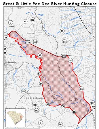
Due to river levels dropping faster than initially predicted, the temporary closure of the Little and Great Pee Dee Rivers that was originally set to expire at midnight on Saturday, Oct. 29 will now expire at midnight on Thursday, Oct. 27, allowing hunting to resume in these portions of Marion, Georgetown and Horry Counties beginning Friday, Oct. 28.
Great Pee Dee and Little Pee Dee River Drainages:
Marion County All areas south of U.S. Highway 378 and bounded on the west side by the Great Pee Dee River and on the east side by the Little Pee Dee River.
Horry County West side boundary beginning at U.S. Highway 378 at the Little Pee Dee River, thence south along the county line and Little Pee Dee River to the confluence of the Great Pee Dee River, thence southeast along the Great Pee Dee River to U.S. Highway 701. East side boundary beginning at the Georgetown County line at the Great Pee Dee River on U.S. Highway 701, thence north on U.S. Highway 701 to State Road 24 (Pee Dee highway.) thence north on State Road 24 (Pee Dee highway.) to U.S. Highway 378, thence to the Little Pee Dee River.
Georgetown County West side boundary beginning at the Great Pee Dee River at the Williamsburg County line, thence west along State Road 5 (County Line Road) to the intersection with Old Pee Dee Road (State Roads 14, 55, and 36), thence south and east along Old Pee Dee Road to the intersection with U.S. Highway 701. Eastside boundary beginning at the intersection of State Road 36 (Old Pee Dee Road) and U.S. Highway 701, thence northeast to the Great Pee Dee River, thence northwest along the Great Pee Dee River to State Road 5 (County Line Road).
| Area | Personnel | Number |
|---|---|---|
| Coastal, Midlands | David Lucas | 843-610-0096 |
| Marine | Erin Weeks | 843-953-9845 |
| Upstate, Midlands | Greg Lucas | 864-380-5201 |
After Hours Radio Room - 803-955-4000

