
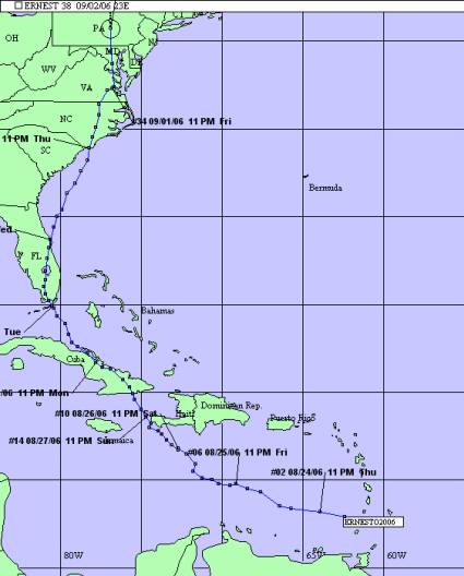
August 24-September 1, 2006
South Carolina Department of Natural Resources
Land, Water and Conservation Division
South Carolina State Climatology Office
Compiled by Mark Malsick
Tropical Storm Ernesto was the first tropical cyclone of the 2006 hurricane season to threaten South Carolina. Luckily, Ernesto never became organized after a series of landfalls and cross-country journeys over Cuba and Florida. Synoptic steering kept Ernesto offshore South Carolina, and only the weaker, western half of Ernesto's cyclonic circulation brushed South Carolina's coastal counties from Charleston to Horry County. Horry County was most affected by Ernesto, recording 35-40 knot wind gusts and 6-7 inches of rain. Ernesto passed South Carolina August 31 and made landfall in North Carolina with 50 knot winds and 8-15 inches of rain.
Tropical Storm Ernesto began as a Cape Verde tropical wave that traveled across the Atlantic and became the fifth tropical disturbance of the 2006 hurricane season on August 24. The National Hurricane Center upgraded this disturbance to Tropical Storm Ernesto after it passed over the Lesser Antilles and strengthened rapidly in the eastern Caribbean (Figure 1).
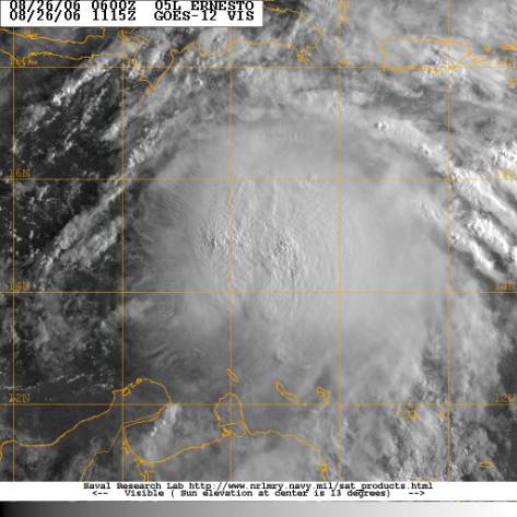
Figure 1. Tropical Storm Ernesto over the eastern Caribbean
As Ernesto tracked slowly west-northwest, under the influence of the sub-tropical ridge, Ernesto briefly strengthened to a 65-knot hurricane on August 27, near the western tip of Haiti (Figure 2).
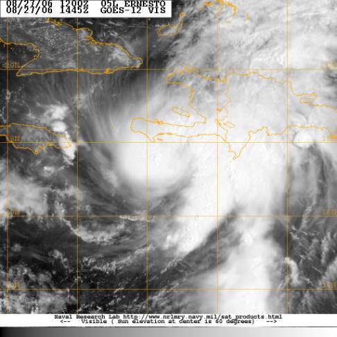
Figure 2. Hurricane Ernesto
While south of Haiti, Ernesto's forecast track shifted dramatically from a Gulf Coast landfall shown in Figure 3 to a track that directly threatened a landfall along the South Carolina coast (Figure 4).
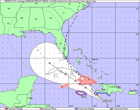
Figure 3. 5-day NHC forecast track issued 11PM EDT August 26.
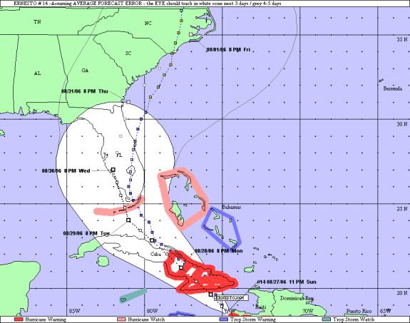
Figure 4. 5-day NHC forecast track issued 11 PM EDT August 27.
Ernesto weakened to a disorganized tropical storm as it tracked over the Windward Passage and subsequently made landfall near Guantanamo, Cuba. Ernesto slowed significantly over eastern Cuba allowing the topography to disrupt Ernesto's surface inflow, further weakening the tropical storm.
Ernesto emerged from Cuba during the early morning hours on August 29 as a weak 30-knot tropical storm that then passed over the Florida Strait, making a second landfall in southern Dade County, Florida. Ernesto lumbered overland up the Florida Peninsula August 29-30, re-emerging over the Atlantic near Cape Canaveral at midnight August 30. While over Florida, Ernesto weakened to a 25 knot tropical depression. Over the warmer Atlantic waters, Ernesto strengthened throughout the day August 31 to 60 knots while passing within 60 miles of Charleston (Figure 5). Ernesto trudged ashore on the coast of Brunswick County, North Carolina, then continued northwards leaving a soggy, rain-soaked trail through eastern North Carolina, Virginia, and Maryland.
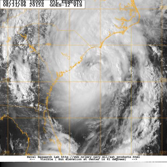
Figure 5. Tropical Storm Ernesto August 31.
Tropical Storm Ernesto remained disorganized due to passing over Cuba and Florida and a dearth of upper level support. Steering Ernesto was the sub-tropical ridge to the east and a developing 500 mb trough over the Ohio River Valley to the west shown in Figures 6 and 7 respectively. Weakness developing in the sub-tropical ridge and the cut-off development of the 500 mb shortwave were responsible for the sudden shift in the August 27 NHC 120 hour forecast track for Ernesto. Numerical model consensus was consistent with Ernest0's track forecast with the Canadian Global Environment Multiscale (GEM) handling the eastward track shift the most accurately. As Ernesto tracked over Florida there was excellent consensus amongst the models for the track of Ernesto to remain offshore South Carolina.
As with any disorganized tropical storm, Ernesto's intensity forecast was always problematic, specifically the forecast for Ernesto's intensity after it re-emerged over the Atlantic late on August 30. Satellite analysis and Melbourne National Weather Service Forecast Office's WSR-88 radar provided valuable clues to Ernesto's future intensification while over Atlantic waters. Figure 9 shows an extensive cloud shield with imbedded convection that proceeded Ernesto's return emergence from over Florida. This cloud shield and gusty imbedded winds moderated sea surface temperatures, which prevented the possibility of any rapid intensification of Ernesto. The elongated appearance of Ernesto also suggested an increasing shear environment that would also prevent Ernesto from reaching hurricane intensity prior to landfall in North Carolina.
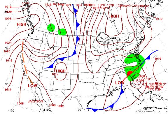
Figure 6. Surface fronts and analysis 7 AM EDT August 31 (Courtesy NOAA-HPC).
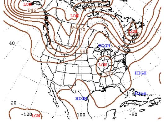
Figure7. 500 mb geopotential heights 7 AM EDT August 31 (Courtesy NOAA-HPC).
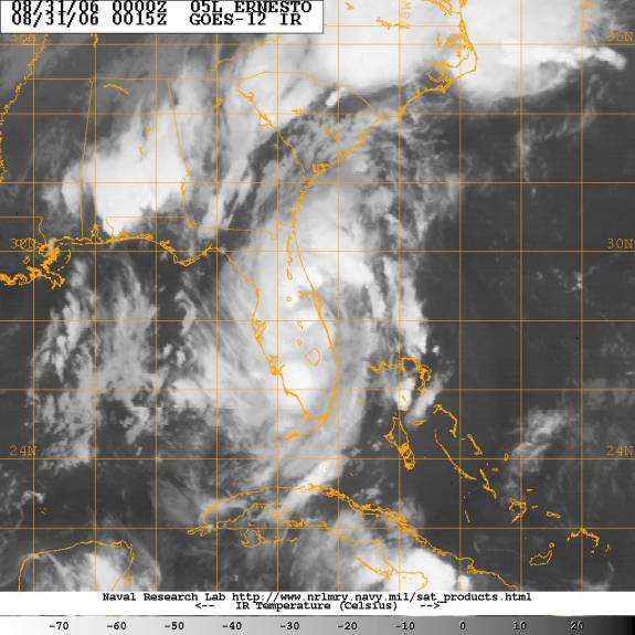
Figure 8. Infrared image of Ernesto as it began to emerge from over Florida.
Tropical Storm Ernesto caused only minimal damage to the South Carolina coast, as it scraped by offshore on August 31. The heaviest rains occurred in Charleston and Horry Counties. Several streets in downtown Charleston including portions of Highway 17 were flooded temporarily. Numerous roads in Horry County were flooded and impassable with up to four feet of standing water in some locations. Only minor beach erosion was reported along the South Carolina coast due to the offshore winds from Ernesto.
| City | Rainfall (inches) |
City | Rainfall (inches) |
|---|---|---|---|
| North Myrtle Beach Airport | 7.20 | Mount Pleasant | 6.82 |
| McClellanville | 6.35 | Myrtle Beach FD | 6.30 |
| Daniel Island | 4.50 ++ | Conway | 4.02 |
| Socastee | 3.39 | Johns Island | 3.35 |
| Goose Creek | 3.00 | West Ashley | 2.96 |
| James Island | 2.69 | Charleston Airport | 2.61 |
| Isle Of Palms | 2.52 | Downtown Charleston | 2.24 |
| Fort Moultrie | 2.12 | Goose Creek | 2.04 |
| Summerville | 2.00 | Mullins | 1.81 |
| Galivants Ferry | 1.77 | Folly Beach City Hall | 1.70 |
| Edisto Beach | 1.44 | Dillon | 1.35 |
| Moncks Corner | 1.28 | Marion | 1.23 |
| Seabrook Island | 1.05 | Givhans | 0.86 |
| Ridgeville | 0.83 | Beaufort | 0.47 + |
| Hilton Head | 0.46 + | Bluffton | 0.29 |
| Pritchardville | 0.22 |
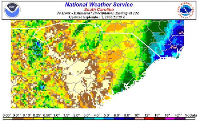
Figure 9. Radar-derived rainfall estimates from Topical Storm Ernesto.
North Myrtle Beach Airport 38 knots from 350o at 0258 UTC 09/01/06
Charleston SC Airport 28knots from 010o at 1754 UTC 8/31/06
Savannah GA Airport 22 knots from 340o at 1810 UTC 8/31/06
East Cooper SC Airport 31 knots on 8/31/06 - No time or direction available
Charleston SC Executive Airport 28 knots on 8/31/06 - No time or direction available
Official Coastal/Marine Sites:
NDBC 41004 Edisto Buoy 54 knots from 320o at 2153 UTC 8/31/06
NDBC 41008 Grays Reef Buoy 31 knots from 020o at 1247 UTC 8/31/06
CMAN FBIS1 Folly Beach 32 knots from 000o at 1929 UTC 8/31/06
Springmaid Pier Myrtle Beach 39 knots from 000o at 2200 UTC on 8/31/06
Sabsoon Navy R2 Tower (50m.) 37 knots at 1400/1500/1700/1800 UTC 8/31/06
Sabsoon Navy M2R6 Tower (50m.) 41 knots at 1532 and 1832 UTC 8/31/06
Miscellaneous Sites:
Downtown Charleston, SC 31 knots From 347o at 1828 UTC 8/31/06
Pineville, SC 26 knots from 330o at 0150 UTC on 9/1/06
Walterboro, SC 17 knots from 000o at 2100 UTC on 8/31/06
The South Carolina Emergency Management Division activated the Emergency Operations Center on August 29 when the National Hurricane Center began forecasting Tropical Storm Ernesto to make landfall on the South Carolina coast. The Emergency Operations Center remained staffed until September 1. There were no mandatory evacuations. Schools in coastal counties were closed as a precaution and several emergency shelters were opened when Ernesto threatened to make landfall August 31.
Special thanks to the National Oceanic and Atmospheric Administration and its many divisions for the wealth of weather and climate data made available to prepare this report. Specific thanks to:
Additional thanks to the Naval Research Laboratory Monterey's Marine Meteorology Division for the well-cataloged library of satellite imagery used for this report.
end