
South Carolina Department of Natural Resources
Land, Water and Conservation Division
South Carolina State Climatology Office
Compiled by Mark Malsick
Hurricane season 2005 was a record-setting period of tropical cyclone activity that both surprised and amazed hurricane forecasters. The 2005 season saw 28 named storms of which 15 were hurricanes. Seven of those hurricanes were classified as intense hurricanes with sustained winds over 110 mph. Even more incredible was that 3 of those 7 intense hurricanes, Katrina, Rita, and Wilma, had winds above 155 mph and were the strongest, most destructive storms yet seen in modern times.
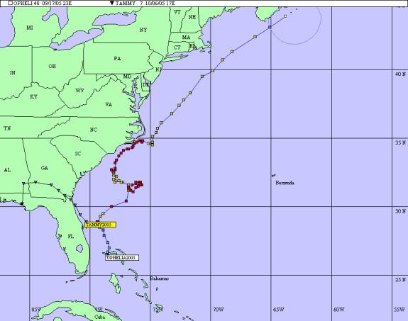
South Carolina was affected by only two tropical storms during the 2005 tropical season. Hurricane Ophelia and Tropical Storm Tammy were relatively weak storms that spared the State the destruction that Louisiana, Texas and Florida saw in 2005. Minor coastal flooding, a few downed trees and beach erosion were the worst calling cards left by Ophelia and Tammy as they brushed by South Carolina.
Hurricane Ophelia, the fifteenth named tropical cyclone of the 2005 tropical season, began as a weak disturbance at the end of a decaying frontal system over the northwestern Bahamas. The National Hurricane Center issued the first forecast for Ophelia on Tuesday, September 6 with the storm loosely centered near the Bahamas.
Ophelia continued to show impressive intensification throughout the day, slowly trudging northeastward at 10 mph, 240 miles southeast of Charleston, South Carolina. A hurricane watch was issued for the South Carolina coast at 11 AM, September 10. The NHC forecasted Ophelia to make landfall along the South Carolina coast on September 13.
Ophelia became a 80 mph hurricane 210 miles east-southeast of Charleston, South Carolina during the afternoon of September 10. The hurricane slowed to 3 mph on a wobbly northeast track. Ophelia proceeded on a slow, clockwise loop 230 miles east-southeast of Charleston, confounding forecasters and emergency managers in the Carolinas. Ophelia's slow crawl over the Gulf Stream caused upwelling of cooler water kept Ophelia's winds weak. NHC reclassified Ophelia as a 70 mph tropical storm on September 12. Ophelia did, however, remain a very large storm with tropical storm force winds extending 140 miles out from the eye.
Ophelia continued a slow, erratic track to the northwest towards the South Carolina coast until the evening of September 13 when it regained minimal hurricane strength over warmer Gulf Stream waters. Ophelia turned away from South Carolina on a more northerly track early, paralleling the North Carolina coast, passing within 30 miles of Wilmington (maximum sustained winds 48 mph gusting to 68 mph) and brushing Cape Hatteras before turning east northeast on September 15.
In South Carolina, Ophelia caused high surf and severe beach erosion at Hunting Island State Park on September 8. Numerous rip currents were reported along the coast from September 8-12. Ophelia's outer rain bands brushed Georgetown and Horry Counties September 12-14, causing downed trees and minor coastal flooding on the sound side of the barrier islands. The North Myrtle Beach Airport recorded 6.3 inches of rain September 12-14. North Myrtle Beach Airport also recorded 23 mph maximum sustained winds and a peak wind of 44 mph.
Tropical Storm Tammy, occurring in early October, was a surprising, short duration coastal storm that rapidly intensified from a persistent tropical wave into a minimal storm. Tammy went ashore along the northeast Florida coast and traveled into southern Alabama but still caused heavy rain and coastal storm damage in South Carolina. Tammy began as a weak easterly wave that tracked slowly across the Atlantic and became a persistent disturbance over the warm tropical waters of the Bahamas. This disturbance menaced the Bahamas with 35 mph winds until early in the morning of October 5, when National Weather Service Radar observations indicated a well-defined surface circulation 40 miles east of Melbourne, Florida. The NHC quickly upgraded this circulation to Tropical Storm Tammy; the 2005 hurricane season's twenty-first storm.
Tammy continued on a northwest track and quickly made landfall by 9 PM October 5 in the vicinity of Mayport, Florida, with 40 mph winds and heavy rain. Tammy rapidly lost intensity while over south-central Georgia as it slowed and spread heavy tropical rain bands along the Georgia coastline and into South Carolina. Prior to and upon landfall, Tammy spread a large, heavy precipitation shield over South Carolina. The strongest winds and convection were in the northern quadrants of the storm. Edisto Beach recorded 59 mph winds as the remnants of Tammy passed. Heavy rainfall in excess of 10 inches was measured in the vicinity of Georgetown and Spartanburg, South Carolina. Georgetown received 6.98 inches of rain in 24 hours on October 7, and a total of 14.88 from the remnants of Tammy. Widespread flooding, downed trees and power lines were widely reported throughout South Carolina.
Significant beach erosion was also reported along the coast with heavy erosion occurring at Edisto Beach where several feet of beach were lost. Beach erosion also occurred along the coast at the Isle of Palms, Tybee Island and Hunting Island. High tide and pounding surf were responsible for the destruction of at least one house at Edisto Beach. Six to eight Edisto Beach city blocks were closed due to sand and debris that blocked roads. Gusty winds blew down 30 trees in Beaufort County and other scattered tree damage was reported along the coast.
