
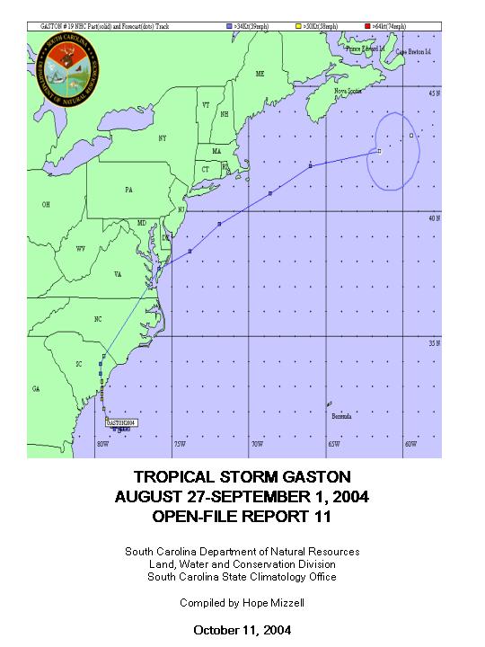
Clouds began brushing South Carolina coastal counties on Thursday, August 26, 2004, as a low pressure began forming along a decaying frontal boundary offshore. By Friday afternoon, August 27, the feature developed into Tropical Depression Seven with the center 140 miles southeast of Charleston. A Tropical Storm Watch was issued for portions of the southeastern U.S. coast from Surf City, North Carolina, southward to Fernandina Beach, Florida. The system was upgraded to Tropical Storm Gaston on Saturday morning (Figure 1), August 28, with Tropical Storm Warnings posted along the South Carolina coast from Savannah River Inlet to Little River Inlet. Gaston strengthened through the day prompting the National Hurricane Center to issue Hurricane Warnings for the South Carolina coast at 7:45 PM EDT. The center of the storm at this time was located 95 miles south-southeast of Charleston. Charleston and Georgetown Counties issued a voluntary evacuation for barrier islands, low-lying areas, mobile homes, beachfront areas, and areas prone to flooding. Initial steering currents for the storm were weak; however, a building ridge to the northeast of Gaston nudged the cyclone northwestward making landfall as a strong tropical storm just south of Cape Romain on Sunday morning, August 29, around 9:30 AM EDT (Figure 2). Peak wind gusts to 82 mph were reported in downtown Charleston and Isle of Palms. Table 1 displays a list of peak wind gusts. A deep-layer trough moving eastward into South Carolina helped push Gaston northward through Williamsburg and Florence Counties before turning to the northeast through Marlboro and Dillon. The system maintained its tropical storm status until 8:00 PM EDT shortly before the center of circulation crossed into North Carolina around 9:00 PM EDT.
The storm flooded areas already saturated by Hurricane Charley earlier in the month and cut power to 172,000 electric customers in the state. Radar rainfall estimates indicated up to 10 inches of rain fell just southwest of the track across Charleston County and up to 8 to 15 inches of rain across northern and eastern portions of Berkeley County. According to the Charleston National Weather Service, there were unofficial reports of around 13 inches of rain in Bonneau and at least 12 inches of rain at St. Stephen. In Berkeley County, 20 structures sustained major damage or were destroyed by flooding. Numerous evacuations and road closures were necessary across northern Berkeley County due to flooding. The National Weather Service in Columbia reported three to five inches of rain in Chesterfield, Lee, Sumter, and Orangeburg Counties with seven inches reported in Clarendon County (Table 2).
Strong winds associated with Gaston lasted for several hours after landfall due to the slow movement of the storm. The wind knocked down power lines, trees, and large limbs resulting in some major structural damage and minor damage to over 3,000 structures. An F1 tornado touched down in Marlboro County, four miles northeast of Wallace, with spotty damage about one mile long and up to one mile wide.
Tropical Storm Gaston was the third tropical system to impact South Carolina during August, preceded by Bonnie and Charley on August 12 and 14. Hurricane Charley was the first hurricane to make landfall in the state since Hurricane Hugo smashed into the coast 15 years ago north of Charleston. For South Carolina, the"one-two punch" from Charley and Gaston was the first time in almost a half-century that two tropical systems made direct landfall on the South Carolina coast during the same storm season. Hurricane Cindy and Hurricane Gracie both stormed ashore in 1959. Two storms did make landfall along the coast in 1976; however, one of the systems was classified as subtropical. Past tracks show storms that make landfall in Florida or along the Gulf Coast and then track into the state over land are far more frequent. During the past 50 years, the historical storm tracks show that 31 named cyclones came into the state through the so-called"back door" compared with 10 that moved into the coast from the Atlantic Ocean.
By the end of August, the 2004 hurricane season was already breaking climatological records. For the entire Atlantic and Gulf of Mexico region, a total of eight tropical cyclones reached storm strength in August breaking the previous record of seven established in 1933 and 1995.
Table 1: Peak Wind Gusts
Downtown Charleston USGS Equipment 		82 Mph/71 Knots
Isle Of Palms					81 Mph/70 Knots
Sullivans Island Fire Station 			78 Mph/68 Knots
East Cooper Airport				73 Mph/ 63 Knots +++
Ladson /NWS Spotter	 			63 Mph/55 Knots =
South Capers Island /NOS Site	 		61 Mph/53 Knots
Downtown Charleston /Coast Guard Station	60 Mph/52 Knots
Pineville					58 Mph/50 Knots
Eadytown					55 Mph/48 Knots
Charleston Airport				55 Mph/48 Knots
Downtown Charleston /Perry Street		55 Mph/48 Knots
Folly Beach C-Man 				51 Mph/44 Knots
Downtown Charleston /Calhoun Street		49 Mph/43 Knots
Johns Island Executive Airport /AWOS		48 Mph/42 Knots
Downtown Charleston 				48 Mph/42 Knots
Hilton Head Airport 				25 Mph/22 Knots

=   	OBSERVATION TAKEN AT 14 FEET
+++ 	OBSERVATION BEFORE WIND EQUIPMENT DESTROYED
Notes:Unofficial lowest pressures at Isle of Palms of 988 mb and South Capers Island of 985 mb. Major erosion on the eastern shores of Lake Moultrie. Many piers and sea walls destroyed or severely damaged in the Bonneau Beach area.
Table 2: Rainfall Summary 8 AM August 27, 2004, to 8 AM August 31, 2004Kingstree 10.50 Cades 9.87 Jamestown 7.05 Turbeville Highway Dept. 7.00 Lake City 6.45 Darlington Airport 6.00 McColl 5.84 Manning Highway Dept. 5.50 Andrew 5.30 Fort Moultrie 5.05 Pineville 5.01 Downtown Charleston 4.63 Dillon 4.46 Florence 4.36 Charleston Airport 4.05 Georgetown County 3.91 Edisto Island 2.20 North Myrtle Beach 1.69
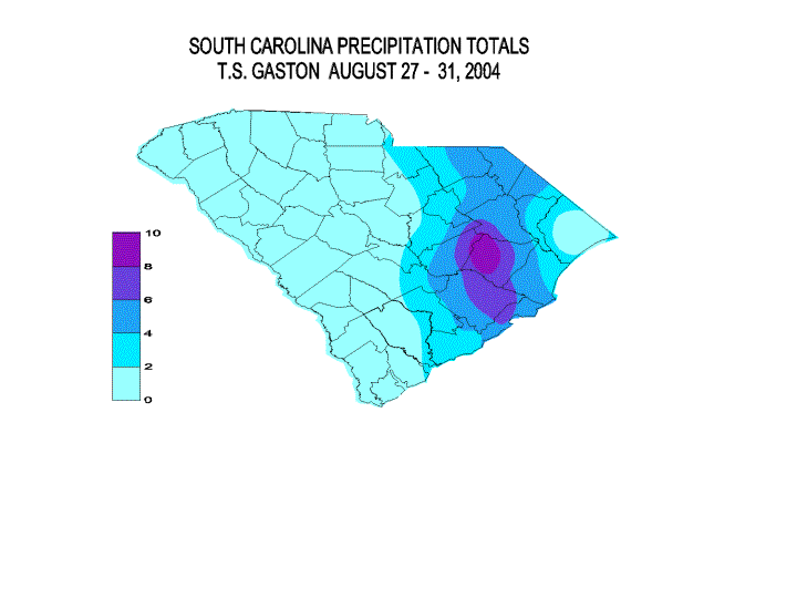
Figure 1: GOES Floater Visible Satellite, August 28, 2004
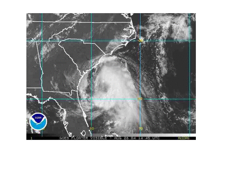
Figure 1: GOES Floater Visible Satellite, August 28, 2004
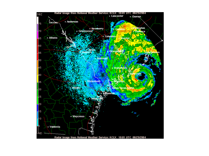
Figure 2: Charleston National Weather Service Radar, August 29, 2004 6 A.M, shows eye approaching the Coast
