A complex series of low pressure systems moved across South Carolina from the 25th through the 27th of February 2004. A 500 mb cut-off low over Texas began to march eastward on the 24th and 25th bringing copious amounts of moisture to regions of the Deep South. At the same time, cold high pressure in Canada began to build over the Great Lakes and New England. The cold air began infiltrating the state from northeast to southwest late on Tuesday and by Wednesday morning temperatures in the 40s statewide set the stage for a potentially major winter storm.
A classic cold air damming event was underway with dewpoint temperatures across the state in the mid teens to low twenties. A mixture of rain and sleet began falling across central South Carolina around noon on Wednesday, February 25th with temperatures in the mid 40s F as the dry atmosphere aloft began to cool through evaporational cooling.
The rain and sleet became more widespread as the night continued into the early morning on Thursday the 26th. Between 1 and 3 a.m., snow began to fall across the Upstate and sleet began to pile up in the northern Midlands as temperatures fell finally into the 30s (temperatures dropped from mid 40s F at midnight to mid 30s F at 4 am).
As the initial disturbance pulled out to sea, a secondary low formed over the lower Mississippi Valley and moved east-north-east to the coastal Carolinas. By mid-morning on Thursday heavy snow was falling across the eastern Upstate counties of Spartanburg, Greenville, Union, Cherokee, Laurens, Chester and York. Even farther south and east, the northern Midland counties of Newberry, Kershaw, Lancaster, and Chesterfield counties began to see snowfall rates increase. Snowfall from the second in the round of three low pressures tapered off in the early afternoon except in the north-central portion of the state where snow continued.
The final disturbance in association with the 500 mb low pressure system progressed toward South Carolina late in the day on Thursday and lingered across South and North Carolina through Friday afternoon. At the same time the coastal low pressure began to intensify. Reports of thundersnow were reported in the Rock Hill area of York County where as much as 22 inches of snow fell throughout the storm with 24-28 inch drifts.
The upper level low pressure system became disjointed from the main surface low on Friday and actually moved from northeast to southwest, an uncommon pattern for winter storms that usually move out to the Atlantic Ocean. This final wave of precipitation brought more light snow and sleet to areas as far south as Columbia on Thursday night when up to 1/2 inch accumulated on roads and even flurries on Friday.
All in all, this storm was historical in many parts of the state, especially in the north-central areas of South Carolina near the North Carolina border. Snowfall/ice totals (inches) issued by the National Weather Service included:
Northern Piedmont, Foothills
and Mountains:
Anderson        3-4
Cherokee        8-10
Spartanburg     8-10
Greenville      5.5
Pickens         .25-.5
Oconee          1

Lower Piedmont, Eastern Piedmont:
Greenwood       1.5-2
Laurens         7-8
Union           12
Chester         6-10
York            18

Midlands:
Chesterfield    10
Lancaster       7-8
Newberry        4-12
Edgefield       1.5
Fairfield       7.5
Kershaw         2-3
Lee             .5 to 1
Lexington       .5
McCormick        1
Saluda           1
Aiken            .25-.5
Sumter           Trace
Richland         .1-.5

Pee Dee:
Darlington       1
Dillon           1.5
Florence        .5
Marlboro         2
The National Weather Service issued numerous Winter Storm Watches and advisories that were later upgraded and expanded to include most of the state along and north of Interstate 20 at some point during the storm. The surprise amounts were received in the counties bordering North Carolina in the eastern Piedmont, northern Midlands, and Pee Dee regions. Meteorologists for the National Weather Service did an excellent job in preparing for the major winter storm that hit South Carolina February 25-27, 2004 giving some 4-5 days of discussion in the pre-storm timeframe.
Several records were established during and after the event, including:

Snowfall map by National Weather Service, Greenville-Spartanburg
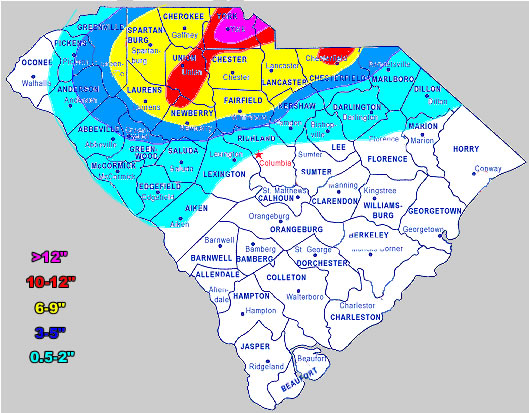
Snowfall map by National Weather Service, Columbia
Pictures below provided by Rock Hill Herald


Jason Caldwell, Severe Weather Liaison
S.C. Department of Natural Resources
Office of the State Climatology
2221 Devine Street, Suite 222
Columbia, South Carolina 29205-2418
(803) 734-9100
