

Comprehensive Spatial Data on Biological Resources and Uses in Southeastern Coastal Waters of the U.S.
The Governor's South Atlantic Alliance, established in 2009, is led by the four southeastern states in partnership with three federal co-lead agencies (National Oceanographic and Atmospheric Administration (NOAA), Environmental Protection Agency (EPA), and USGS), but other GSAA partners include additional federal agencies, academia, nonprofits, private industry, and other regional organizations. The mission of the Alliance is to "significantly increase regional collaboration among the South Atlantic states, with federal agency partners and other stakeholders, to sustain and enhance the environmental (coastal/marine), natural resources, economic, public safety, social, and national defense missions of the respective states and the South Atlantic region." The Alliance established an Action Plan in 2010 and an Implementation Plan in 2011 (available at http://southatlanticalliance.org/) that are focused on four priority issues: Healthy Ecosystems, Working Waterfronts, Clean Coastal and Ocean Waters, and Disaster Resilient Communities. Through grants from NOAA, the Alliance has obtained funding necessary for administrative and programmatic activities, which includes development of a Regional Information Management System (RIMS) as part of one initiative being led by the Southeast Coastal Ocean Observing Regional Association (SECOORA).
 The South Carolina Department of Natural Resources
has been an active participant in the Alliance and has developed or compiled numerous databases describing the distribution and relative abundance
of key biological resources in the region, as well as human use databases. These databases were developed through funding from NOAA as part of a
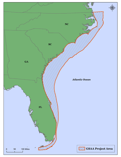
sub-award to SECOORA (NA12NOS4730007). The study region for the data files available on this site generally cover the coastal waters off North
Carolina, South Carolina, Georgia, and Florida from the beach out to the 200m bathymetric contour, where data were available. The more than 50
data layers provided on this site can be downloaded by the user, or viewed directly and downloaded from the GSAA
Coast & Ocean Portal. Most feature data sets (e.g. Finfish Shallow Water) have a number of feature classes (e.g. individual species
information), and separate feature data layer (.lyr) files that provide some interpretation relative to the overall data set (e.g. high, moderate,
low CPUE). The metadata files provide all necessary information on the source(s) of the data and method of processing.
The South Carolina Department of Natural Resources
has been an active participant in the Alliance and has developed or compiled numerous databases describing the distribution and relative abundance
of key biological resources in the region, as well as human use databases. These databases were developed through funding from NOAA as part of a
sub-award to SECOORA (NA12NOS4730007). The study region for the data files available on this site generally cover the coastal waters off North
Carolina, South Carolina, Georgia, and Florida from the beach out to the 200m bathymetric contour, where data were available. The more than 50
data layers provided on this site can be downloaded by the user, or viewed directly and downloaded from the GSAA
Coast & Ocean Portal. Most feature data sets (e.g. Finfish Shallow Water) have a number of feature classes (e.g. individual species
information), and separate feature data layer (.lyr) files that provide some interpretation relative to the overall data set (e.g. high, moderate,
low CPUE). The metadata files provide all necessary information on the source(s) of the data and method of processing.
Project Contact
These data products are made possible by the South Carolina Department of Natural Resources and other State, Federal, and Local sources in the region in support of this project.
If you have any questions please contact:
Frank Tian, tianf@dnr.sc.gov
GIS Data Manager
South Carolina Department of Natural Resources
Final Report
Comprehensive Spatial Data on Biological Resources and Uses in Southeastern Coastal Waters of the U.S. (PDF)
Geographic Coordinate System
UTM, Zone 17, Meters, Datum NAD83
Viewing Data
The best approach for viewing the data is through the GSAA Coast & Ocean Portal. Otherwise, to view the GIS data, you will need computer mapping software. For users without GIS desktop software, a free desktop viewer from ESRI is available. The Resource Center for ArcGIS Explorer from ESRI provides tutorials, Online Help, forum, and related documentation. The TatukGIS Viewer is a free viewer available from TatukGIS.
For other software programs, please consult your particular software's help to determine compatibility with this format and any required software updates and/or plugins.
Download Available Data
Data is available for download at no cost from DNR's ftp site or from the GSAA Data Portal. DNR site last updated January 2013.
- ESRI ArcGIS v10.1 file geodatabases: GSAAGISData201312.zip
- ESRI ArcGIS v9.3 file geodatabases: GSAAGISData201302.zip
Data Contributors


